Optimizing Railway Infrastructure for Mining Using High-Resolution Drone LiDAR Survey Data
Optimizing Railway Infrastructure for Mining Using High-Resolution Drone LiDAR Survey Data

Transporting raw materials from mines to ports efficiently is a critical challenge in the mining industry. In Northern Cape, South Africa, a manganese mine faced high costs and inefficiencies moving material by road. To address this, engineers turned to railway transport, which offers a more cost-effective and sustainable solution. However, upgrading and modifying existing railway infrastructure requires precise data on current conditions. This is where a detailed, high-resolution drone LiDAR survey became essential.
Why Railway Infrastructure Matters for Mining Operations
Railways provide a reliable and economical way to transport large volumes of heavy materials over long distances. For mining companies, shifting from road to rail can reduce fuel costs, lower emissions, and minimize road maintenance expenses. However, designing or modifying railway lines is complex. Engineers must understand the exact position, elevation, and condition of existing infrastructure to plan upgrades that ensure safety and efficiency.
In this manganese mine project, the existing railway needed adjustments to handle increased loads and connect smoothly to export ports. Without accurate data, planners risk costly errors or delays.

How Drone LiDAR Survey Supports Railway Planning
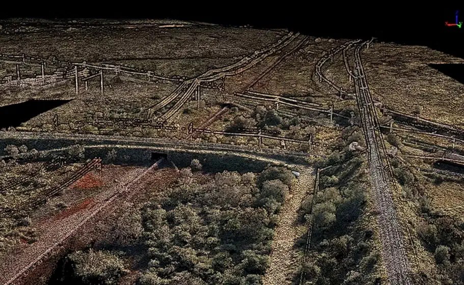
Drone LiDAR technology uses laser pulses emitted from a drone to create detailed 3D maps of terrain and structures. The result is a dense pointcloud—a collection of millions of points representing the surface geometry with high precision.
This method offers several advantages for railway infrastructure projects near mines:
- High accuracy: The pointcloud captures precise levels and positions of tracks, embankments, and surrounding features.
- Speed: Drone surveys cover large areas quickly compared to traditional ground surveys.
- Safety: Drones access difficult or hazardous terrain without putting surveyors at risk.
- Data richness: The 3D model supports detailed analysis and future planning.
For the Northern Cape manganese mine, the drone LiDAR survey provided engineers with a reliable base to model railway modifications and optimize routing.

Practical Benefits for Engineers and Mine Operators
The high-resolution drone LiDAR data transformed how the railway project was planned:
- Improved design accuracy: Engineers used the pointcloud to identify exact track positions and ground levels, reducing guesswork.
- Cost savings: Accurate data minimized the need for costly rework or unexpected construction challenges.
- Better risk management: Understanding terrain variations helped avoid potential hazards during railway upgrades.
- Future-proofing: The dataset serves as a baseline for ongoing monitoring and future infrastructure changes.
For mine operators, the shift to rail supported by this survey means lower transport costs and a more sustainable supply chain.

Moving Forward with Data-Driven Railway Upgrades
The detailed drone LiDAR survey near this mine shows how modern technology supports smarter infrastructure planning. By providing precise, high-resolution data, drone surveys enable engineers to design railway modifications that improve efficiency and reduce costs.
If your mining operation faces transport challenges, consider how drone LiDAR can provide the accurate information needed to build better railway connections. Investing in this technology today can lead to smoother project execution and long-term savings.
Related
Discover more from sUAS News
Subscribe to get the latest posts sent to your email.
Other News in This Category
- WISPR Systems’ SkyScout 2+ Earns Blue UAS ApprovalValidates Platform for Federal and Public Safety Deployment
- Redwire Awarded $20 Million in Follow-On Orders from Navy and Marine Corps Small Tactical Unmanned Aircrafts Systems Program Office (PMA-263) to Deliver Stalker UAS Advanced Navigation and Standard Systems
- Germany to manufacture Ukrainian reconnaissance drones in major defence collaboration
- Ukraine Captures Russian Position Using Only Drones and Ground Robots.