Wingtra’s new white paper validates sub-3 cm accuracy across 102 flights
Wingtra’s new white paper validates sub-3 cm accuracy across 102 flights

Wingtra, the leading manufacturer of drone aerial survey and mapping systems, today released a white paper detailing how its new SURVEY61 payload—carried by its latest WingtraRAY survey drone—delivered consistent sub-3 cm (0.1 ft) accuracy across 102 flights based on rigorous checkpoint verification. The study spanned five sites and involved multiple drones and multiple payloads. This white paper offers surveyors and GIS professionals a concrete, data-backed case for a faster and safer way to work. It also details best practices based on potential points of failure so that the results can be duplicated.
“As an engineer with experience on high-stakes survey projects like the Gotthard Tunnel in Switzerland, I know these numbers matter and that reputations and projects depend on them,” said Andrea Zwick, Product Engineer at Wingtra, and driving force behind the white paper. “This white paper not only offers proof of payload performance but also puts an exhaustive repeat accuracy study in the context of best practices. So it’s not just a report, it’s a tool: customers can use it to apply the best practices and see for themselves that this accuracy is achievable and reliable.”
Cut time in the field without sacrificing accuracy
Setting ground points has always been one of the most time-consuming and safety-critical parts of a drone survey. It’s expensive in the moment, but more importantly it introduces a bottleneck, limiting how frequently teams can fly repeat surveys and reducing visibility around earthworks and as-built progress. The SURVEY61 white paper directly addresses this.
Across 102 flights, the study validates a PPK-based workflow that uses checkpoints only to achieve accuracy well within 3 cm (0.1 ft). In 95% of flights, accuracy stayed below those 2-sigma thresholds. What this means: in applicable cases, ground points can be reduced since accuracy is reliable, i.e., less field hours spent on ground setup.
For earthworks teams running repeat volumetric surveys, GIS analysts tracking site change over time, and survey professionals who need to demonstrate verified accuracy to clients, this changes the math on what’s operationally possible.
Tested across systems: from Propeller to TBC, results are consistent
One of the most important aspects of this study is what it doesn’t control for. The 102 flights were conducted across five different WingtraRAY drones and three different SURVEY61 payloads, at altitudes ranging from 60 to 120 m and across 17 days of winter flying in Switzerland. It also relies entirely on out-of-the-box Wingtra settings (when fine-tune settings are available). The results held.
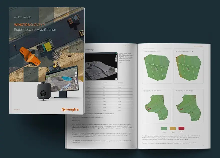
For teams needing reliable data for cut-and-fill analysis, volumetric calculations and drainage change detection, the white paper’s DSM comparisons between consecutive flights confirmed surface differences below 3 cm on stable terrain. And to test payload quality regardless of the processing environment, a dataset was run through Wingtra, Propeller, PIX4Dmatic, Agisoft and Trimble TBC. Every platform returned sub-3 cm (0.1 ft) RMSE.
“The quality of SURVEY61’s optics means the software has everything it needs to do its job correctly,” said Ronny Panier, Systems Engineering Team Lead at Wingtra. “It doesn’t matter which platform you process in. The data is consistent, and the accuracy follows.”
Best practices for the field
The white paper goes beyond just showcasing the results of an in-depth study of one payload. It also provides best practices that empower readers to understand key factors, like baseline distance and the right mix of GCPs and checkpoints. For example, as a rule of thumb, every 10 km between the drone’s GNSS base and the flight area adds approximately 1–2 cm of positional error.
This kind of practical guidance, grounded in real test data, is shared to help field teams plan correction strategies that match their accuracy requirements while benefiting from accuracy so reliable and repeatable that they can reduce their ground setup and risk exposure significantly.
Access the full study
The complete white paper—including site-by-site breakdowns, DSM comparison visuals, baseline analysis tables and processing reports across five software platforms—is available here. Deeper dive appendices with all 102 flight checkpoint statistics and sample datasets for independent review are also published here.
About Wingtra
Wingtra is a leading aerial insights company for mapping and surveying applications.
Founded in Switzerland in 2017, it develops the only drone solution built specifically for surveyors that covers the entire workflow. From easy flight planning to CAD- and GIS-ready outputs, surveyors walk through guided and connected steps. No more switching tools or guesswork. The result? Survey-grade results in hours—not days. In fact, today, large, renowned companies, government agencies and universities around the world turn to Wingtra for trusted data, no rework, and a more cost-effective way to survey.
Related
Discover more from sUAS News
Subscribe to get the latest posts sent to your email.